
Aviation Weather
Aviation weather can be fairly hard to understand sometimes. The application of theoretical meteorology to the practical world of aviation takes an immense amount of skill. Luckily, our online ground school courses were created with the help of experienced airline Captain and certified meteorologist Doug Morris. However, not all ground schools are lucky to have such a skilled and knowledgeable contributor create some fantastic images and share practical stories.
In this article, we will focus a little bit on where to get some weather information and how to broadly apply that to pre-flight briefings.
How do you check aviation weather?
A briefing in aviation begins with a wide look at the weather to see what giant systems, such as high and low pressures, are doing on a large geographical scale. This broad view gives pilots the idea of what is going on now and what might be happening in the future. Although private pilots engaged in pilot training may not find this useful, this information sets a good foundation on which to contextualize local area forecasts.
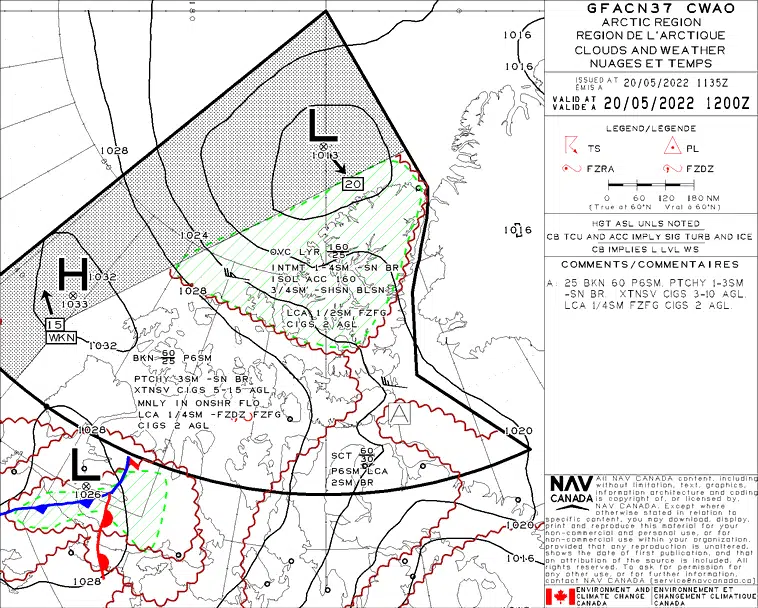
Once the pilot understands the broad trends in Canada, they may generally move onto the Graphical Area Forecast, or GFA. The GFA narrows down the geographical area of Canada into smaller sections and allows pilots to see regional trends on the weather. Pilots must keep in mind that the GFA is still a forecast, the weather which can be seen on it may not occur.
This is when we narrow our focus down to our route of flight or to the geographic vicinity in which we are flying. Now that we have the large picture, we can see how it influences our planned flight mission. Pilots will then use local area aviation weather forecasts and reports, such as Terminal Area Forecasts and METARs, to see the local trends. Actual pilot reports (PIREPs) and METARs are used to confirm or deny the forecasted aviation weather from the GFA and from the TAFs.
If the actual weather is the same as the forecasts, pilot may increase their confidence in the forecasts. If the actual reports and the forecasts do not align, pilots must take a step back and second guess the aviation forecasters.

Aviation Weather Products
- NAV Canada Weather Website: This is the primary Canadian Aviation Weather Resource pilots go to when preparing to fly within Canadian Airspace.
- NAV Canada Satellite Imagery: Satellite Imagery provides pilots with cloud information. Where are they? How are they moving over time? Animated (moving) Satellite Imagery Maps are usually updated in 3 hours increments. GOES Satellite Imagery shows you where the clouds are from a Geostationary Satellite (top down view). It does not show cloud tops, layers or bottoms. Talk to Flight Services for that.
- Environment Canada Weather Radar Imagery: Radar Imagery provides pilots with “big picture” precipitation information. How much water is in the air? Where is it? All the Information comes from Radar Sites on the ground.
- Environment Canada Weather Quick View: 7-day Forecast
- American Weather: NOAA / Aviation Digital Data Service (ADDS) USA – The Aviation Digital Data Service (ADDS) makes available to the US and Canadian Aviation Community; text, digital and graphical forecasts, analyses, and observations of aviation-related weather variables. This is the “no cost site” when you are planning to fly in the USA.
- ADDS Satellite Visible Moving Map: NOAA / Aviation Digital Data Service (ADDS) USA – VIS (Visible) Imagery is depicted by showing the area that clouds occupy. This is a black and white moving map depiction of clouds as they move over a 3 hour time period. Most parts of Canada are also seen.
Pilots can always call a flight information center for a briefing on their flight conditions by calling 1-877-WXBRIEF in Canada. Your local flight school may have their own sources of aviation meteorological conditions which may be better suited to your local area. Please consult with a local flight instructor for more personalized information.